Thursday, June 30, 2011

First Saturday Outing - July 2

The Dan River Basin Association's First Saturday Outing on July 2 will be a 5-mile round-trip paddle on Philpott Lake from Ryan's Branch to Emerson Falls.

Meet at Ryan's Branch on the Union Bridge Road (GPS 36.849853,-80.10227).
Dress in layers of synthetic fabric, wear sunscreen and hat, and bring boat, paddles, life jackets, lunch and water.

Free and open to the public.

For more information contact: Craig S. Rockwell, 276-629-4512 Ex 224, Craig.S.Rockwell@usace.army.mil

Monday, June 27, 2011

PHILPOTT LAKE PHOTO CONTEST

Here is your chance to enter your picture and a chance to win some fantastic prizes including money (Based on the number of entries)???
PHILPOTT LAKE PHOTO CONTEST
THIS CONTEST IS INTENDED FOR ANYONE REGARDLESS OF AGE


1. THERE WILL BE A $15.00 DONATION FOR EACH ENTRY. ENTRANTS MAY ENTER AS MANY TIMES AS THEY WISH.
ALL PROFIT FROM ENTRY FEES WILL GO TO THE BOWENS CREEK HANDICAP WELLNESS PARK.For the purposes of this Contest, no judges or anyone associated with judges, including family members, will be able to enter.


2. CONTEST ENTRY PERIOD: The Contest Entry Period begins at 12:00:00 a.m. Eastern Time (“EST”) on April 18, 2011 and ends at 11:59:59 p.m. EST on June 30, 2011. Entries must be received and recorded by Photo Contest Manager’s computer during the Contest Entry Period. The Photo Contest Manager’s computer is the official time keeping device for the Contest.


3. TO PARTICIPATE: To participate in the Contest, contacted Linda Drage by email ldrage@comcast.net during the Contest Entry Period and follow the instructions to enter and upload a creative, well composed and well lit photo of the Philpott Dam/Lake in any direction


THE DAM NO LATER NEEDS TO BE IN THE PICTURE. Each photo must have a signed entry form. Signed forms maybe mail to Linda Drage; 330 Mack Rd., Martinsville, VA 24112. All photos must be sent by email. By participating, you agree to be bound by these Rules and the decisions of the judges, which are final and binding in all respects


By submitting an Entry, you hereby grant Sponsor consent, the right to copy, publish, display and otherwise use your Photo for purposes of the this Contest or for any advertising or publicity on behalf of the Sponsor and you agree that the Photo may be cropped, or otherwise altered for this purpose only. The Entrants will still remain the owner of the photo.


All Entrants must have a valid email address. In the event of a dispute regarding Entries received from multiple users having the same email account, the authorized subscriber of the email account at the time of submission will be deemed to be the Entrant and must comply with these Rules

4. PHOTO SUBMISSION GUIDELINES:


  • Photo must be in JPEG format

  • Photo must be an attachment not imdded in the email

  • Photo may not be sexually explicit or suggestive, unnecessarily violent or derogatory of any ethnic, racial, gender, religious, profane or pornographic, cantain nudity or any dangerous activity.

  • Photo may not promote alcohol, illegal dugs, tobacco, firearms/weapons (or any use of any of the foregoing), any actiities that may appear unsafe or dangerous, or any particular political agenda or message

  • Photo may not be obscene or offensive, endorse any form of hate or hate group

  • Photo may not defame, misrepresent or contain disparaging remarks about Sponsor or other people, products or companies.

  • Photo may not contain trademarks, logos or trade dress owned by others, or advertise or promote any brand or product of any kind, or contain any personal identification, such as license plate numbers, personal names, e-mail addresses or street address.

  • Photo may not contain copyrighted material owned by others (including potographs, sculpture, paintings and other works of art or images published on or in websites, television, movies or other media).

  • Photo may not communicate messages or images inconsistent with the positive images and/or goodwill to which Sponsor wishes to associate
    Photo may not depect, and cannot itself, be in violation of any law
    ENTRIES POSTED TO THE EMAIL ADDRESS ABOVE WILL NOT BE EDITED BY SPONSOR FOR THE CONTEST AND ARE THE VIEWS/OPINIONS OF THE INDIVIDUAL ENTRANT AND DO NOT REFLECT THE VIEWS OF SPONSOR IN ANY MANNER.

5. WINNER SELECTION: All eligible Entries will be judged by independent judges, whose decisions regarding this Contest are final and binding in all respects, based on the following criteria: (a) 40% Adherence to Theme, (b) 30% Creativity, (c) 15% Composition and (d) 15% Focus/Lighting. In the event of a tie, the tie will be broken based on the highest score in the “Creativity” Judging Criteria. If a tie continues, then a tie(s) will be broken by the Entry with highest cumulative score in the second criteria, continuing thereafter to the third criteria, as needed, to break the tie the three Entries with the highest scores will receive a prize as set forth below.


6. PRIZES: One (1) First Prize: The Entrant with the highest score will receive a check for half the amount from total entries. The Entrant with the second highest score will receive a prize to be stated later; as well as the Entrant with the third highest score. Each Entrant will receive a Dam Post Card from the Dam Collectables. Limit one (1) prize per person. If a prize, or any portion thereof, cannot be awarded for any reason, Sponsor reserves the right to substitute prize with another prize of equal or greater value. Prizes won by minors will be awarded along with minor's parent or legal guardian, who must sign and return form.


7. WINNER NOTIFICATION: Winners will be notified on June 30, 2011. Sponsor is not responsible for any change of email, mailing address and/or telephone number of Entrants.
8. GENERAL CONDITIONS: By participating, Entrants agree to these Rules, which are final and binding in all respects. If the Winner cannot be reached within ten (10) business days of notification or winner is found to be ineligible or not in compliance with these Rules, prize will be forfeited. By entering, each winner grants (and will confirm that grant in writing) permission to Sponsor the right to use the winner’s name, picture, likeness, voice, biographical information, and Entry (whether modified, edited, used alone, or used with other works) at any time, in any form, in any media, without compensation of any kind and without notice, review, or approval. Entrants further agree that submission of an Entry is gratuitous and made without restriction, and will not place Sponsor under any obligation.
You will need to certify that you are the photographer and sole copyright owner of the submitted Photo, and you have obtained consent of all identifiable persons shown in the Photo for use by Sponsor as set forth herein. By signing you are agreeing to the terms of the contest.You can get your form by emailing request to Linda Drage: ldrage@comcast.net or calling me at 276-681-6805. You can also pick -up at the Bassett Community Market any Thursday afternoon from noon to 3:00 PM.

Thursday, May 19, 2011

Smith River Mini-Triathlon

Smith River Mini-Triathlon


Run
: 1.2 miles along the beautiful Smith River   Paddle: 1.2 miles on the Smith River's class I rapids. Bike: 2.5 miles on paved and natural surface terrain. Experienced mountain bikers for bike leg. Awards for 1st, 2nd, 3rd place finishers. All pre-registered participants receive a T-shirt. Classes: Solo-Youth, Male, & Female. Team-All Male, All Female, Coed different age increments. Call 403-5140 for more inf. Registration brochures are online at www.martinsville-va.gov/Parks-and-Recreation.html  or call us for a registration brochure.
DATE/TIME: Saturday, May 21, Registration and check in 9am-9:45am. Race starts at 10am 
11:15am-Awards ceremony at Trailhead
LOCATION: Fieldale Trail Head, (Off River Rd., Fieldale, VA)
FEE: $15 per participant, $20 fee day of the event
Kayaks & Canoes available to rent - $15 - Smith River Outfitters, Must reserve kayaks by calling 252-0701  or canoes - 403-5140 & they will be onsite.
You’re invited!
Draper Landing to Berry Hill Float June 4


Join in DRBA’s seven-mile float on the Dan River from Eden’s Draper Landing Access to Berry Hill Bridge on June 4, coordinated by Will Truslow, DRBA’s past president.
Meet at 10:00 a.m. at the access’s graveled parking lot beside the NC 700 Bridge to set the shuttle (GPS 36.4987, -79.6814). Three Rivers Outfitters of Eden, 336-627-6215 or www.3-R-O.com, will offer boat rentals and shuttle for the float, which will end on private property with the owner’s permission.
In this river trip of Class I water, participants will navigate at least seven ledges and shoals with long-standing historic names found on old maps. Six of these have been made easier to navigate by structures such as sluice walls built in the nineteenth century by the Roanoke Navigation Company (founded 1812), a joint effort of Virginia and North Carolina, and by the US Army Corps of Engineers. The sluice walls concentrate the river’s water at shallow ledges, creating a narrow channel deep enough to float long, narrow batteaux, the commercial “semi-trailers” of early river travel.
 
Nearly a century before the river was improved for navigation, in 1728 a survey team led by Virginia’s William Byrd determined the “dividing line” between North Carolina and Virginia. Byrd named the Dan River for the river in northern Israel and gave names that still survive to many of the river’s tributaries. One was Cascade Creek, which enters from river left about halfway through the trip, so called “by reason of the multitude of waterfalls that are in it” some distance before it reaches the Dan.
 
Devil’s Jump Shoal, just downstream from Cascade Creek, is named for impressive mid-river rocks. On river right less than a mile downstream from Devil’s Jump is the confluence of the Dan with Tanyard Creek, named for the tannery owned by John Morehead, father of North Carolina Governor John Motley Morehead, who grew up nearby.
 
Between two old sluice walls of Tanyard Shoal, separated by nearly a half-mile of the Dan’s flow, is a place called on an 1823 survey “The Wreck,” according to William E. Trout III, author of the Dan River Atlas. “Why?” he asks, inviting future river mappers to solve the mystery.
Other examples of intriguing nineteenth-century labels are Beasley’s Gallows Shoal Sluice and the well-preserved Hairston’s Fish Trap Sluice, likely modified from an Amerindian fish weir of 1000 years ago.
The trip is part of the series of over 100 First Saturday Outings that have been offered by DRBA almost from its inception. Other interesting facts about the geology, history, and culture of this section of the river are found in Maps 42 – 45 of “An Insider’s Guide to the Dan River in North Carolina and Virginia,” available at www.danriver.org
.


Participants in the outing are asked to provide boat, life jacket, lunch and water, to dress in layers of artificial (quick-drying) fabric and to sign a waiver.


Directions: To reach Draper Landing Access (GPS 36.4987, -79.6814) from the north or west, take NC 14 to NC 700 East. Travel on NC 700 about 4 miles through Eden to the bridge over the Dan River. After crossing the bridge, go 0.1 mile and turn left into the gravel driveway to the access.

From the south take US 29 North, turning left (west) on NC 700. Just past Quesinberry Road, turn right into the gravel driveway to the access beside the NC 700 Bridge over the Dan.

From the east take US 29 South, turning right (west) on NC 700, and proceed as described above.


More information:
For trip information, contact trip coordinator Will Truslow, 336-547-1903,
willtruslow@hotmail.com

336-627-6270 http://www.danriver.org

Tuesday, May 10, 2011

Axton Elementary say's "Bye Bye trout"


Its Monday morning on the Smith River at Bassett Virginia and vivacious group of young students pile out of the big yellow bus, excited to be out of school and ready for an adventure on the river.  These students from Hannah Sullivan's class at Axton Elementary have been raising brown trout (with a little help from their teacher) for the past 6 months in a tank in their classroom.  They are one of 31 tanks across 4 counties in one of the country's single largest Trout in the Classroom Programs, TIC in Southern Virginia !


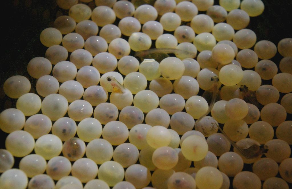
 Each year, students and teachers get brown trout eggs from the state hatchery at Wytheville in December,  The tiny pinkish / orange eggs are only a few weeks old when the schools first receive them and these "eye-up" eggs are placed in breeder baskets made of netting and suspended off edge of the tank.
Its not long before the first trout start to "break out of their shell" and get their first look at a new environment. 

Often, the first thing the new trout see are many eyes on the outside of the tank, staring back at them !
By Christmas the fry have hatched are now called alevins,  Just a few weeks later and the "sac fry" have absorbed all their yolk sacs and are ready to start eating trout food.

Once the trout are big enough to be "swim-ups"  they are released from the breeder net in to the tank.  By May, the trout are now big, fat and healthy and are known as "fingerlings" and at this stage  they are ready to be released in the Smith River.

The students and teachers help take care of the trout and have to make sure the water is cleaned and the trout are fed.  They also have to make sure the water is the correct ph and the ammonia levels are low.
The students are learning that trout need good clean water to survive.  So now the big day has arrived and they are ready to take theses trout they have been raising and let them go into their new river home.
On this day, The Dan River Basins new Executive Director, Tiffany Haworth, donned rubber boots and joined the students as they introduced the trout to their new home.

After the last trout swam out to deeper water, it was time for the students to take a "stream walk" and learn more about the river and what the trout were going to eat now that they would not be fed each day by the students.


On the stream walk the students learned that bugs like stoneflys, mayflys, helgramites and crayfish (macro-invertebrates) live under the rocks and logs in the river.   A seine net was used to capture some of the macros for closer examination.

 It was another great day in the best classroom in the world...the river
Thanks to Hannah and Patrick Sullivan, all the students and teachers at Axton Elementary and a special thanks to Tiffany Haworth for helping the kids stay "mostly" dry during the stream walk experience !

Tuesday, April 12, 2011

DRBA First Saturday Outing for May

DRBA Paddles the Dan in Stokes County
DRBA’s May 7 First Saturday Outing will be a 5-mile paddle trip on the Dan River in Stokes County from Snow Creek Access to Hemlock Golf Course Access coordinated by Will Truslow. 
 Meet at 10:00 a.m. at the Snow Creek Access, about 200 yards west of Dodgetown Road Bridge on Pitzer Road (GPS 36.4026, -80.1404), to unload boats and gear and set the shuttle.

For boat rentals and shuttle, contact Three Rivers Outfitters, 336-627-6215 or 276-340-3983, www.3-r-o.com, or Dan River Company, 336-593-2628, www.danrivercompany.com.

History and legend abound on this section of the river, which is characterized by high bluffs forested with hardwoods and stands of stately hemlock trees. Just upstream of the put-in is the frame of the Pitzer Steel Truss Bridge, dating from 1918.

About half a mile below Snow Creek is Thompson’s Fish Dam, which has remnants of a rare wooden slat trap. According to “An Insider’s Guide to the Dan River,” a “heavy timber frame, about eight feet square, formed a grid of slats” to trap fish channeled into the trap by a vee-shaped low rock wall.

At least two branches of the Great Wagon Road forded the river at shoals on this section, and caves are said to have been used by Confederate draft dodgers.

Rock formations and uncommon Carolina hemlock stands have received recognition as the Dan River Cliffs natural heritage area.

According to Truslow, “This section of the Dan has the last of the really high bluffs before the river winds on into the Piedmont. Some are about 150 feet high.” 

The most spectacular is Davis Bluff, a dramatic rock face on river left where huge boulders lie in the water at the base of the cliff. Legend says that a member of the Davis family fell to his death from the road on top. To this day, the cliff is known as Mount Horrible.

The Dan River in this section is rated mostly as Class 1, but the remains of a former Duke Power dam, dynamited in 1975, create a sometimes challenging Class 2 rapid. Fortunately, it is located within sight of the take-out ramp at Hemlock Golf Course.

Meet at 10:00 at the Snow Creek Access on Pitzer Road. Arrange to supply boat, paddles, life jackets, water and lunch; wear water-shedding artificial fabric or wool (not cotton, and certainly not blue jeans); and provide a back-up change of clothing. All participants will be asked to sign a waiver.

Directions: At the intersection of NC 8 and NC 89 about 3 miles south of Danbury, NC, turn northeast onto Dodgetown Road. Drive about 4 miles and cross the Dan River. Immediately turn left onto Pitzer Road. Snow Creek Access is on the left in about 200 yards.

Driving south from Virginia on US 220, turn west on NC 770 to Sandy Ridge. Turn south on NC 704 to Prestonville. Turn south on NC 772 toDodgetown. Turn right onto Dodgetown Road and drive about 4 miles. Just before crossing the Dan River, turn right onto Pitzer Road. Snow Creek Access is on the left in about 200 yards.

More Information: Will Truslow, 336-547-1903, willtruslow@hotmail.com
spacer (1K)

Tuesday, April 5, 2011

New Walking Trail Opens at PHCC

Cutting a ribbon to open a new trail at Patrick Henry Community College and the city reservoir are (from left) Ron Epperly of PHCC; Jennifer Doss, tourism director and formerly with the Dan River Basin Association; Brian Williams of DRBA; Martinsville Mayor Kim Adkins; Jim Frith of Frith Construction, which had the contract to build the trail; Martinsville City Manager Clarence Monday; City Parks and Recreation director Gary Cody; and Jeff Mansour of the Harvest Foundation, which paid for the trail. Thanks to a unique partnership between Patrick Henry Community College, Martinsville City, The Harvest Foundation and Dan River Basin Association, the community has a new hiking and biking trail through the woods around the beautiful Beaver Creek Reservoir. The project was funded by Harvest with in-kind donations from Martinsville City Parks and Recreation Department. Land easements were provided by PHCC and Martinsville City. The project was developed by Dan River Basin Association (DRBA) and trail construction was completed by Frith Construction Company. Additional work was provided by Boy Scout Troop 63 which built benches and picnic tables that were installed by Martinsville Parks and Recreation at various points along the scenic trail. The Beaver Creek Reservoir is also known as the Martinsville Reservoir and is a source of drinking water for the City of Martinsville. The natural setting of this beautiful lake makes it ideal for hiking, fishing and nature viewing. Surrounded by steep hills and lush forest, canoeing, kayaking and fishing are also favorite activities at the lake. The trailhead and parking is located at the upper level parking area adjacent to the Frith Building on the campus of Patrick Henry Community College. Students and the general public have easy access to the trail from campus parking lot. Future plans include extending the trail around the edge of the reservoir and connecting it to a parking area located across the lake from PHCC, at the end of boat ramp drive. The trail is considered a multi-use trail and is open to hiking, mountain biking, running, and nature viewing. Trail users are asked to “share the trail” and help keep the area clean and beautiful by “taking only photographs and leaving only footprints”. PHCC Trail Loop of the Beaver Creek Reservoir Trails & Smith River Trail System is approximately 3/4 of a mile long natural surface trail to be used by hikers, mountain bikers, and to be utilized as an out-door classroom for PHCC students.

www.DanRiver.org