Thursday, November 27, 2008

Encouragment from a Golden Sneaker

Students at Albert Harris Elementary were squirming in their seats anxiously waiting for the big surprise Activate had for them. Grinning ear to ear when Activate staff unveiled the first place 2008 golden sneaker award, the children squealed with joy when it was presented to principal, Natasha Rowell.

But that was only the beginning of the surprise as Jeannie Frisco, Activate Program Director presented a life-size check to the students and faculty for having the most participation of any school in the International Walk to School Day event.

Martinsville Middle School placed second in the event and students were already contemplating how to take first place in 2009. Patrick Henry Elementary placed third and is working on 100% participation for the next challenge.

Monday, November 24, 2008

Thanksgiving Leaf-a-thon

The Dan River Basin Association is pleased to announce that construction officially began on Phase II of the Fieldale Trail today! Workers from Frith Construction brought out leaf blowers to clear the path and used equipment to smooth the ground surface and remove bumps. The workers have made it about 1/3 of the way for this first stage of the trail building process. Other equipment will soon follow behind to complete the surface. We expect the entire 1.5 miles of trail to be completed by the end of December!

In order to save the contractors some time and conserve money in our budget, I am recruiting volunteers to finish blowing the leaves. This will save the contractors a time consuming step so that they can focus on driving the machinery. We will be blowing leaves on Wednesday & Friday, think of it as a "Thanksgiving Leaf-a-Thon"!

If you own or have access to a gas or battery powered leaf blower and want to spend some time out of your Thanksgiving Holiday giving to a good cause, please contact Jennifer Doss to sign up for a time slot. This is an excellent way to work off the turkey and stuffing! :-)

Happy Thanksgiving to all from Team DRBA!

To sign up:
office: 276-634-2545
cell: 276-340-3139

Saturday, November 22, 2008

Volunteers Restore Historic Cemetery


This morning, Team DRBA and a crew of volunteers braved bitter 24 degree weather to help protect and preserve a piece of Henry County history. Fourteen helpers total gathered at the historic cemetery of Uncle John and Jane Burgess, located on Old Mill Road near the Gravely Nature Preserve.


The volunteers worked to cut saplings and remove debris while DRBA staff located, marked, and inventoried grave sites. Vernon Hairston and Jennifer Doss are shown above cutting trees that had taken over the cemetery.

A total of 18 graves were located. The burial sites of four individuals were positively identified by family members and a list of eight others known to be buried somewhere in the cemetery was compiled. Myla Barnhardt of the News & Record came to cover the project and interview descendants of Uncle John and Jane Burgess. Excitement filled the air each time someone yelled "I found another stone!"

After cleaning up the cemetery, the group traveled to God's Love Ministries in Ridgeway to enjoy a pot-luck lunch and share information about their ancestors. Approximately 25 family members gathered at the church, including the last three living grandchildren of Uncle John and Jane.

Grandson Timothy Carter Jr. shared stories about uncle John's dirt floor cabin and playing in Burgess creek. Grandaughter Mary Burgess Hall (pictured above with son, Michael Richardson) remembered the red horse that Uncle John loved to ride. Generations both young and old all were able to learn new and interesting facts about their family.


Since the cemetery has never been documented before, family members were eager to fill out ancestry charts that will help DRBA and the Virginia Department of Historic Resources formally document the property and protect it. Samuel Hairston of Eden and Dorothy Jean Hairston of Ridgeway are shown below sharing stories of their common ancestors.


Norris Funeral Services Inc. of Martinsville has donated an engraved stone cemetery marker for the project and the family worked together to write an appropriate inscription. The marker, to be installed within the next few weeks, will be engraved with the following message:

Burgess Family Cemetery

In loving memory of
Uncle John and Jane Burgess,
former slaves and residents of
the Burgess Plantation
circa late 1800s
and their decendants
laid to rest here.

Gone but not forgotten...


The family enjoyed looking at photos of Uncle John and Jane provided by the descendants of plantation owner John Henry Burgess and reading a 1930s obituary for Uncle John Burgess provided by the Bassett Historical Center. They plan to raise funds in order to purchase fencing and return for a second workday in early spring to install it around the family plot.

Many thanks to land owner James Morrison for allowing us access to his land, to Pastor Ronald Hairston for allowing us to use his church, and to Norris Funeral Services Inc. for their generous donation of an engraved stone cemetery marker.

Click here to see more photos taken by Brian Williams.


Article by Jennifer Doss
Photos by Brian Williams and Jennifer Doss

Tuesday, November 18, 2008

Christmas Trees for Sale

Gateway has a new fundraiser for 2008! We have grown some handsome Scotch Pine trees and they are ready to adorn your home or business for Christmas 2008. The trees are ready to be cut and will be sold on a first come, first serve basis.
We will cut them and trim their base as we get orders for them. They can be picked up at our municipal tree farm at 300 Clearview Drive in Martinsville. We have twenty seven trees to be sold and the price will be $25.00 per tree. The trees range in size from five feet tall to fifteen feet tall.

You may visit the farm and choose your tree if you wish. You will have a fresh cut tree and will be helping promote our mission of enhancing Martinsville and Henry County through your donation. Call 634-4674 or 634-4622 to choose a tree and to reserve a tree.

Article and photos contributed by: Lois Christensen

Posted by: Vicky Thomas

Monday, November 17, 2008

Dan River Basin Fly-over

October 31, 2008

A crisp fall day and clear blue skies provided some lucky Dan River Basin Association staff an opportunity to take to the sky and view our beloved river basin from a perspective quite different than we normally do. A planned flight over the basin had been postponed several times in the past few months but now it was finally going to happen. Our flight today was courtesy of SouthWings. SouthWings is a non-profit organization that offers, free of charge, flights to other non-profits, over areas of environmental concern. "Conservation through Aviation" is their guiding mission.

Excerpt from Southwings website:


"We enable those we fly to see beauty and human-induced landscape change in our environment from another, otherwise inaccessible, vantage point. Utilizing the aerial perspective, SouthWings' service provides experiential understanding of environmental challenges and opportunities for conservation. This perspective fosters understanding of scale/magnitude and the relationship of cumulative and compounding environmental effects."

We are extremely grateful to SouthWings for this unique opportunity to learn from the sky !

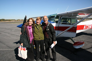
Our pilot, Susan Lapis (who was fabulous), flew into Danville Regional to pick up the DRBA crew for the day. Katherine Mull, Jeffrey Johnston and Lindley Butler were scheduled to make the flight, but Dr. Butler had a conflict so he reluctantly gave his seat up...and I was the lucky one to take his place. Cameras, maps, and GPS in hand, we boarded the Cessna 182 as Susan made last minute pre-flight checks. "Please be sure your seat backs and tray tables are in their upright and locked position. Flight crew, prepare all seats for departure."


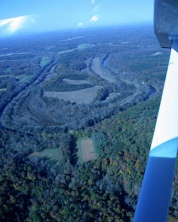
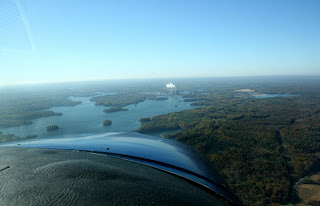
Indifferent to earth's gravitational constraints, we powered down the runway and lifted into the great wide open with the Dan River stretching out before us, a shimmering ribbon of life beckoning us to follow the watery highway.


Gaining altitude and speed, Susan deftly banked to the west and coaxed the plane along the flanks of the Dan as we began our journey cruising at 800 feet and, gliding over town and countryside, past fields, farmlands and forest, the headwaters calling with its siren song from deep in the Kibler Valley gorge.


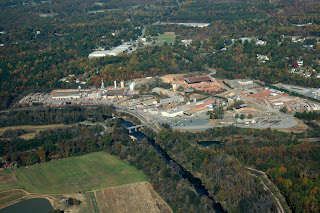
The city of Danville quickly came into view, its tobacco warehouse district sprawling along the south side of the Dan, arched bridges spanning the river connecting new development and industry with the rich history of a once vibrant tobacco based economy. Just across the river lay the 1908 site of the Wreck of the Old 97 made famous in a popular tune and recorded by countless artists, the site today reduced to nothing more than a historic marker on the side of the road.


There were several areas of concern, and we photographed as many sites as we could that we felt contribute to overall degredation of the river corridor.


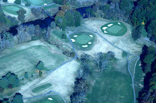
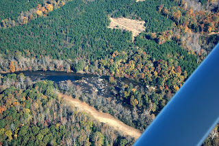
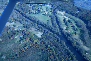
Some obvious threats to the river included clear-cuts and bad land management practices. Less obvious and even a bit scenic were several golf courses that bordered the river. The effects of sediment loads from erosion and groundwater runoff are obvious forms of pollution, but the golf course can have a negative impact as well from heavy fertilizer runoff into the river.


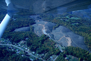
Other erosional problems were obvious in areas heavily used by 4-wheel drive and off-road vehicles.


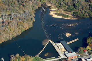
Susan was an outstanding pilot, and she was able to keep just south of the river affording Jeff and myself with ample opportunities for photographs and observation. I felt a bit sorry for Katherine on the other side of the plane as she had to settle for the occasional glance of the river as we banked to get a better view or follow a sharp bend. We positioned ourselves about 800 ft. above the river and were torn between flying lower to photograph the historic batteau channels, wing dams and native American fish weirs, famous along the Dan, or staying high enough to get a broader perspective of the landscape to better locate clear cuts and other riparian issues.


We chose to stay at an elevation that would afford us the best view of the overall landscape while still getting a close look at the river itself. Perhaps a future flight can be directed toward river structure photo graphic surveys.

A conspicuous "Y" shaped junction came into view, and we knew we had reached the confluence of the Smith and Dan Rivers.


We left Eden behind and continued on across Rockingham and into Stokes county, arching around the edge of sprawling Belews Lake with its myriad islands and conspicuous power plant. The lake was just visible to me over the nose of the plane, but Katherine was finally afforded a decent view without straining across to look out the opposite window!


The Pine Hall brick manufacturing facility was an obvious landmark along the river. From here to Kibler Valley, the terrain would now be predominantly farmland and forest.


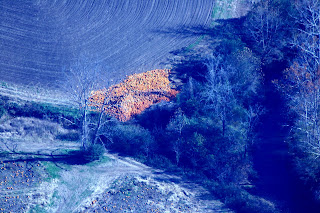
Passing over a large field on the edge of the river, we noticed a corner filled with bright orange pumpkins discarded after the harvest. Did they just plant too many or were these pumpkins that didn't make the cut? It was a fitting tribute to our Halloween flight.


After what seemed like a mere 5 minutes, Susan informed us we had been in the air for over an hour! Wow, time really does fly!

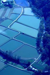
Just ahead was a large aquaculture operation right along the river bank. We wondered what, if any, detrimental effects this operation could be having on the river aside from a poor riparian buffer.


The landscape was changing once again and Hanging Rock was looming to the south. We were flying level with this prominent land feature when Susan decided we needed to climb a little higher due to the rapidly increasing elevation of the surrounding land.


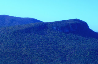
The view was spectacular but it seemed like a good idea to keep it below us rather than next to us. As we climbed to 3000 ft., we had the most spectacular view as the wild beauty of the Kibler Valley gorge opened in front of us and seemed to swallow the silver ribbon we had been following for the past hour. There was no doubt that this place was still wild. Few roads run through this rugged terrain, and a thick carpet of hardwood forest and precipitous mountains effectively hide the sparse encroachment of civilization through these rugged mountains.


This is most undoubtedly the "Jewel of the Dan River Basin," and we should be ever vigilant in our efforts to protect and preserve this incredible wild area. …to be continued.

next post: Kibler Valley, Philpott Lake and the Smith River corridor

Article and photos by Brian Williams
Edited by Vicky Thomas

Wednesday, November 12, 2008

First Saturday Outing, December 6


DECEMBER 6
DRBA TO HIKE MOORE'S WALL LOOP
AT HANGING ROCK STATE PARK

DRBA's December 6 outing will be a moderately strenuous 5-mile hike on Moore's Wall Loop Trail at Hanging Rock State Park near Danbury, NC. Meeting at 10:00 at the bathhouse parking lot in the park, participants will begin the hike at the 1938 stone bathhouse, built by the Civilian Conservation Corps and now on the National Register of Historic Places.

Coordinated by Outings Chair Paul Johnson, the hike will approach the summit of Moore's Knob through a series of switchbacks and then return down a steep descent. Along the way, the trail passes along the shore of Hanging Rock Lake, follows the aptly named Cascade Creek, provides a view of Indian Face rock formation, and reaches a spectacular 360-degree view from the observation tower at the top. The summit of the quartzite mountain rises some 1000 feet above the surrounding countryside.

Participants in the outing are asked to supply lunch and water, to wear hiking boots and layers of artificial (quick-drying) fabric or wool, to be ready for rain or wind, and to sign a waiver.

DIRECTIONS:
Two miles north of Danbury on NC 8/NC 89, turn south onto Hanging Rock Road (SR 2015). Drive two miles to the park entrance at the end of Hanging Rock Road. After entering the park, drive up the mountain past the Visitor's Center entrance to the end of the road at the bathhouse parking lot.

FURTHER INFORMATION:
Paul Johnson, kpauljohnson@yahoo.com or 434-579-7599.


***SPECIAL NOTE***

The 25th Annual Sprig Outing will be held on the Upper Little River on the same day, December 6. For more information about this traditional mistletoe-gathering excursion into a beautiful Carolina swamp, click here.


Article and Photo by: T Butler
Posted by: Vicky Thomas

Tuesday, November 11, 2008

25th Annual Sprig Outing


25th Annual Sprig Outing
On Upper Little River
Saturday, December 6, 2008

Are you planning to deck the halls? Do you have access to a canoe or kayak? Can you borrow a long-handled tree pruner or a painter’s pole with a grappling hook? Then join the warmly and gaily appareled boaters at Hardee’s in Lillington, North Carolina at 10:00 Saturday, December 6, to caravan to the Upper Little River, tributary of the Cape Fear.


After a briefing, participants will caravan to a private landing place on the river in hopes of capturing some prime specimens of phoradendron flavescens, otherwise known as the familiar holiday parasite mistletoe.


“Don’t worry too much about being cold,” says veteran sprigger Forrest Altman, who initiated the Sprig Outing as chairman of the Headwaters group of the Sierra Club while living in Durham. He’s been going back virtually every year for the last quarter century. “On some sunny December days I’ve found myself putting my jacket back in my dry bag.” Why travel that far? Why not get out the shotgun? “Because shooting damages the trees—and the mistletoe,” Altman explains. And because mistletoe and holly grow profusely—and sometimes down low—in Southern swamps. “And because cooperating in coaxing the mistletoe down out of the trees is great fun. Let’s just hope the grey-white berries will be ripe and fat on time this year,” Altman continues. “They aren’t always.”

Participants should dress warmly in polypropylene and wool and bring boat, life jacket for each person, lunch and water—and a change of clothes in case of an upset. Some paddling skill is advisable. The group will put in, paddle upstream on relatively flat water for about a mile, stopping to cooperate in culling the most gorgeous specimens of mistletoe and holly. Shortly after negotiating one mild rapid they’ll have lunch by some sprightly and musical rapids and then head back downriver, heading home well before dark.


Altman, who has been seeking his successor as Sprig Outing coordinator for some years, may finally have found some takers. Leaders of the Tar Heel Paddlers will be present on this year’s trip to become more familiar with the river and get acquainted with the landowner who has been host of the event for several years. Over the years, the Sprig Outing has drawn participants from several Sierra Club groups, from the Dan River Trail Association, Dan River Basin Association, the Carolina Canoe Club, the Lumber River Canoe Club, Triad River Runners and the Tar Heel Paddlers.

DIRECTIONS:
  • To reach Hardee’s in Lillington from Raleigh, take either US 401 or I-40 / NC 55 / US 401 to Lillington. After crossing the Cape Fear River, travel about two blocks to Hardee’s on the right.
  • From Durham, take NC 55 to Fuquay-Varina, US 401 to Lillington.
  • From Greensboro, take US 421 South through Siler City and Sanford. In Lillington, turn right at the traffic signal on US 401 South.
  • From the east or west Lillington is reachable on NC 27.
  • From the southeast take NC 210.
For further information or to receive information about mistletoe or past Sprig Outings, call Forrest Altman at 336-234-8556 or e-mail forrestaltman@mebtel.net.
Article contributed by: Forrest Altman
Photos contributed by: Wayne & Betty Kirkpatrick
Edited and Posted by: Vicky Thomas & T Butler

www.DanRiver.org